REVIEW · PORTLAND
Mt. Hood & Multnomah Falls Air Tour by Envi Adventures
Book on Viator →Operated by Envi Adventures, LLC · Bookable on Viator
Mt. Hood from the sky is a whole different thing. This private air tour from Portland-area base flies you toward Oregon’s tallest peak and then strings together big-name gorge sights you’d normally need a long drive to stitch together. You also get a pilot who talks through what you’re seeing, not just a quiet ride.
I especially like the small-group setup (max 5 travelers), because it keeps the experience more personal and means less waiting around. I also like that the flight includes bottled water and that the pacing is tight—about an hour total—so you get a lot of scenery without burning a whole day.
The main thing to think about is the trade-off: this tour is very weather dependent, and your route may shift at the pilot’s discretion. That matters most if you’re chasing a specific angle of Mt. Hood.
In This Review
- Key Things I’d Plan Around Before You Fly
- From Troutdale Hangar to Takeoff: What This Tour Feels Like
- Willamette Valley First: A Calm Warm-Up Over the Region
- Mount Hood Up Close (But Not Exactly Like the Photos): Wy’east and the FAA Limit
- Mount Hood National Forest: Seeing Structure, Not Just Trees
- Beacon Rock: A Monolith That Looks Like It Belongs in a Movie
- Multnomah Falls Twice: Two Passes, Two Angles, One Big Water Moment
- Sandy River and Latourell Falls: Less Famous, Still Visually Worth It
- Vista House and Crown Point: The Gorge’s Most Photogenic Perch
- Bridge of the Gods: The Quick Transit Moment That Still Means Something
- How Much Value Do You Get for $279? (And Who It’s Best For)
- The Pilot Makes or Breaks It: What the Reviews Hint at
- Weather, Haze, and Short Windows: The Reality of Flying This Region
- Should You Book This Mt. Hood & Multnomah Falls Air Tour?
- FAQ
- What is the duration of the Mt. Hood & Multnomah Falls Air Tour?
- How much does the tour cost?
- Is this a private tour?
- What’s included in the price?
- What’s not included?
- How weather-friendly is this tour?
- What type of aircraft is used?
- How many travelers are allowed?
- Are there any weight limits?
- Where do I meet the tour?
Key Things I’d Plan Around Before You Fly
- Private-feeling flight in a small plane: max 5 travelers, so you’re not stuck in a crowd.
- Expect route changes due to weather: the pilot may adjust the track to find good visibility.
- Mt. Hood is limited by flight rules: there’s a published expectation risk if you’re trying to match close-up photos.
- You’ll see real geology, not just scenery: from flood-cut features to volcanic rock formations.
- Gorge highlights happen fast: Beacon Rock, Multnomah Falls, Vista House, and Crown Point come in quick passes for photos.
- Local operators with talkative pilots: multiple pilots (including Carrie, JP, John, Davis, Spencer, and Clay) are described as informative and friendly.
From Troutdale Hangar to Takeoff: What This Tour Feels Like
Your tour starts at Envi Adventures at 1350 NW Perimeter Way, Troutdale, OR 97060. You’ll want to arrive at least 30 minutes early, because check-in is part of the experience and the flight runs on a tight schedule.
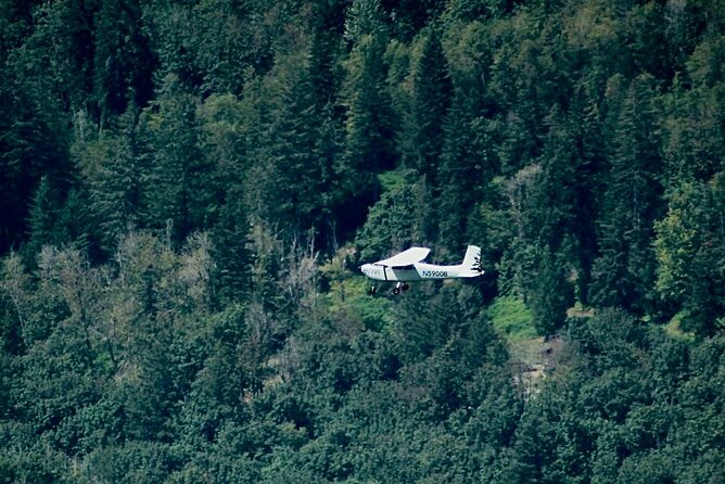
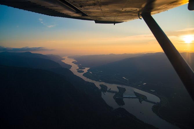
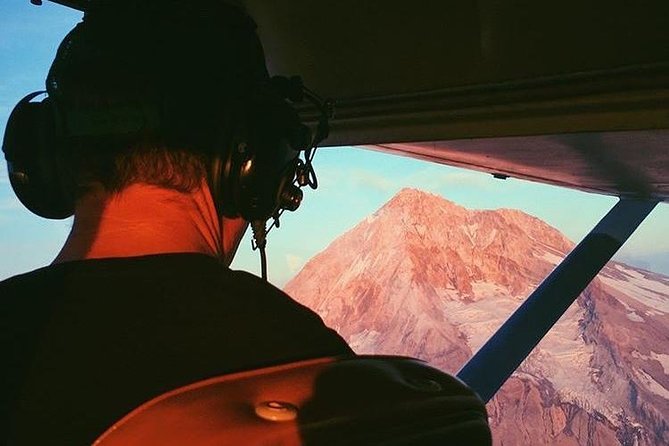
The vibe is practical and low-stress. You’ll fly in airplanes, not helicopters, and that usually means smoother “see-a-lot quickly” sightseeing at the cost of fewer photo-perfect chances than you’d get from a much longer hover-style flight.
Group size stays small—up to 5 travelers—and the experience is described as private for you and your party. In plain terms: you’re likely sharing the cockpit conversation and the viewing windows with only a handful of people.
You can also read our reviews of more tours and experiences in Portland.
- The Real Portland Tour: City and 3 Lighthouses Historical Tour with a Real Local
★ 5.0 · 1,448 reviews


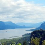
Willamette Valley First: A Calm Warm-Up Over the Region
The flight begins with about 30 minutes over the Willamette Valley, with admission included for that segment. This timing is smart. It gives you a chance to settle in, find your seat comfort, and get used to what the windows offer before the bigger “wow” moments arrive.
If you’re the type who gets motion sickness, starting with the broader, lower-stress terrain can feel easier than going straight toward higher relief. And even if clouds roll in later, you may still catch something nice during this first block.
A downside to keep in mind: 30 minutes can pass quickly. If you’re hoping to memorize every bend and road from above, you’ll need to focus fast—this is a flying sightseeing tour, not a long, slow cruise.
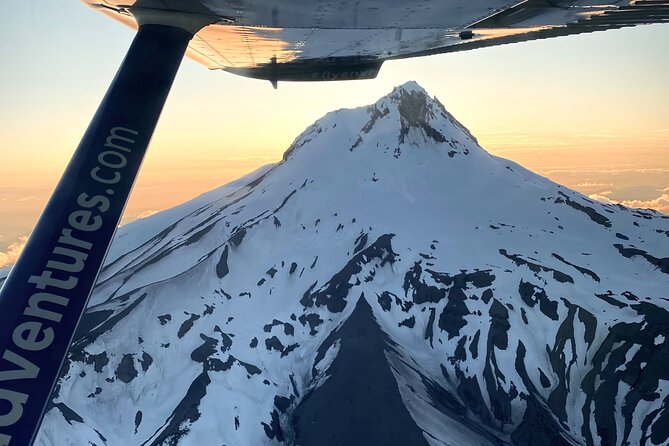
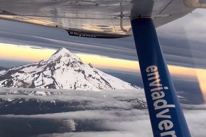
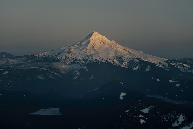
Mount Hood Up Close (But Not Exactly Like the Photos): Wy’east and the FAA Limit
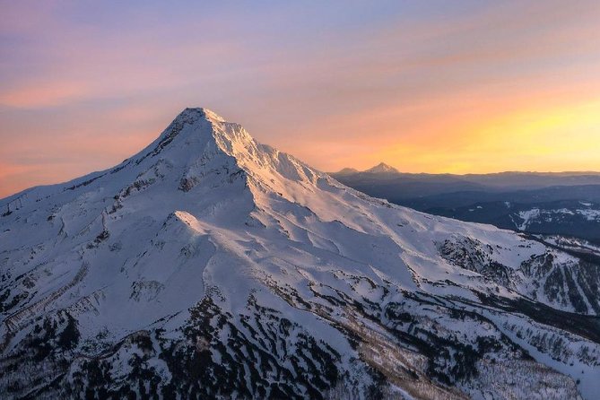
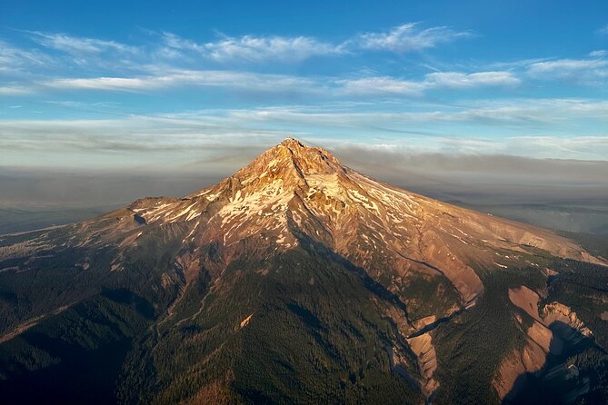
Then comes the headline: Mount Hood. The name Wy’east is part of Multnomah tribal tradition, and the mountain is described as a potentially active stratovolcano in the Cascade Volcanic Arc. From above, it’s the kind of view where you understand why people plan trips around the peak even when they’re not “mountain people.”
Expect about 15 minutes over Mount Hood. There’s also additional time around the broader area, including 15 minutes over Mount Hood National Forest, so the flight doesn’t just touch the summit and move on.
Now for the one expectation-management point that matters: there’s a rule limiting how close the flight can get from the airport. The operator response explains flights must stay within a 25-mile radius (an FAA requirement), and routes may shift due to weather—still within that radius. So if you’re buying specifically to match certain close-up Mt. Hood images, you should assume your exact angle can vary.
This is where the good news is: pilots can still find impressive perspectives within the allowed area. And if visibility is clear, the mountain can look shockingly close even without matching the exact photo-style shot you saw online.
Mount Hood National Forest: Seeing Structure, Not Just Trees
The Mount Hood National Forest segment gives you another 15 minutes, and the value here is different from “look at the mountain.” From the air, forests read as patterns—shades, textures, and clear breaks created by terrain and weather.
If you’re a photography person, this is often when you learn what your camera can actually do. Windows, glare, and speed all affect the outcome, so the forest stretch is your chance to get comfortable shooting through the conditions you’re dealing with that day.
The possible drawback is also simple: if clouds hang low over the forest line, you might not get much detail. But even then, you can often still read the valley forms and mountain edges, which can be enough for great images.
Beacon Rock: A Monolith That Looks Like It Belongs in a Movie
Next, you get a quick 2-minute pass over Beacon Rock, and it’s worth taking seriously. Beacon Rock is described as a 57,000-year-old volcanic plug of a cinder cone, part of the Boring Lava Field, and shaped dramatically by the ice-age Missoula Floods.
That flood story matters because it’s a reminder that this gorge region wasn’t only “scenic”—it was carved. From above, Beacon Rock’s isolation makes more sense. It doesn’t look like a normal hill you’d walk to; it looks like a piece of rock that got dropped into the river system.
Because it’s only a couple of minutes, be ready to shoot immediately. You won’t get a slow, turn-by-turn “window session”—it’s a quick flyby, then on to the falls.


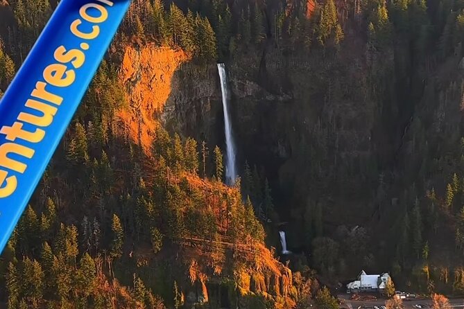
Multnomah Falls Twice: Two Passes, Two Angles, One Big Water Moment
You’ll see Multnomah Falls more than once, with 2-minute segments each time. The falls are described as the most visited natural recreation site in the Pacific Northwest, with more than 2 million visitors each year.
What I like about seeing it from the air is how geology and water connect. Multnomah Falls is fed by underground springs from Larch Mountain, and the flow varies—usually highest in winter and spring. Even when it’s not at peak volume, the fall’s position and surrounding gorge features show clearly.
You also get a geology lesson baked in. The area is described as one of the best places in the Columbia River Gorge National Scenic Area to study flood-exposed geology. From the sky, you can often spot why the floods mattered: the river carved, the rock resisted, and the result is a dramatic canyon layout.
The small trade-off: those 2-minute stops mean you’re capturing the moment rather than soaking it up. If you want a longer, ground-level experience at the falls, you may still enjoy adding time before or after your flight.
Sandy River and Latourell Falls: Less Famous, Still Visually Worth It
Between the major icons, you get a 5-minute flight over the Sandy River. It’s described as a 56-mile tributary of the Columbia River, joining about 14 miles upstream of Portland. From above, tributaries can look like different personalities—narrower, braided, or shifting—depending on the day’s conditions.
Then you’ll catch Latourell Falls in about 2 minutes. It sits along the Columbia River Gorge within Guy W. Talbot State Park, and it’s near the Historic Columbia River Highway. The tour’s air angle means you can see the falls in context even when road visibility is limited.
These segments can be a highlight if you like the “whole system” approach. They’re not just the headline attractions; they show the gorge network working together.
One consideration: because the stops are short, you should decide ahead of time which moments you care about most. I’d treat this flight like a photography sprint—prioritize your must-have views.
Vista House and Crown Point: The Gorge’s Most Photogenic Perch
Toward the end, you’ll fly past major viewpoint landmarks, including Vista House and Crown Point State Park, each for about 2 minutes. Vista House is perched atop cliffs at Crown Point, and this area is described as a popular stop for millions who visit the Columbia River Gorge each year.
From the air, the value is obvious: you’re not only looking at a building or a viewpoint—you’re seeing the cliff geometry and the gorge drop-offs that make the structure dramatic. It’s the kind of shot that helps you understand the scale if you’ve only ever driven through the region.
Since both segments are brief, plan to shoot and then let the experience sink in afterward. The aerial perspective is fast; the memory often lasts longer than the photo.
Bridge of the Gods: The Quick Transit Moment That Still Means Something
You’ll also fly past the Bridge of the Gods, described as a steel truss cantilever bridge spanning the Columbia River between Cascade Locks, Oregon, and Washington state near North Bonneville.
It’s a short moment, but I like these “connector” views. They remind you that the gorge isn’t just a park-like backdrop; it’s a lived-in transportation corridor with historic engineering.
And if you’re a map person, seeing the bridge helps you mentally connect the earlier waterfall icons to the broader geography.
How Much Value Do You Get for $279? (And Who It’s Best For)
At $279 per person for about 1 hour, this isn’t the cheapest way to see Mt. Hood and the gorge. But it can be excellent value if you’re time-crunched or if driving would cost you a full day.
Here’s the value math that matters: you’re getting wide aerial perspectives of multiple landmarks—Mt. Hood, Beacon Rock, Multnomah Falls, Vista House, and more—without spending hours behind the wheel. You also get bottled water, plus the tour is described as a private-feeling flight for your party with a maximum of 5 travelers.
This price also makes sense for people who care about photography and “big picture” views. From the ground, you’ll often see one attraction at a time. From the air, the region reads like one connected story.
Who it suits best:
- Couples and small families who want a high-impact outing
- Photographers who can work quickly with short flyby moments
- Anyone who wants to see more of the Gorge without long drives
- People who don’t want a full day dedicated to transportation
Who might be disappointed:
- Anyone who expects a long hover-style flight or guaranteed close-up Mt. Hood angles like specific online photos
- Anyone who hates weather uncertainty, since the tour is explicitly weather dependent
The Pilot Makes or Breaks It: What the Reviews Hint at
A recurring theme is that the experience is strongly tied to the pilot’s approach. Several named pilots—Carrie, JP, John, Davis (and Dave), Spencer, and Clay—are described as friendly, informative, and careful.
One review detail that I file under “good signs”: at least one pilot has been described as letting a daughter steer the plane for a moment, and other comments mention safety instructions that are short and clear. Even without getting hands-on, that kind of attitude usually shows up as calmer passengers and better explanations.
If you want a smoother ride, show up early, follow the instructions, and bring a positive attitude about changing visibility. Weather can shift your route; good pilots compensate by finding angles that still work.
Weather, Haze, and Short Windows: The Reality of Flying This Region
This tour is clearly very weather dependent, and the operator notes that an alternate route may happen at the pilot’s discretion. Translation: if clouds or haze block the peak, you might not get the same look you imagined—and you may see different angles of the gorge instead.
There’s also a note from one experience describing hazy conditions due to regional wildfire smoke. That’s another reminder that in this part of the Pacific Northwest, skies can change fast.
What you can control:
- Pick a date when you have flexibility
- Dress for changing temps (air flights can feel cooler)
- Bring patience for quick flybys and shifting routes
The best strategy is to treat this as a views-and-geography outing, not a single-shot mission to a perfect summit photo.
Should You Book This Mt. Hood & Multnomah Falls Air Tour?
Yes, I’d book it if your goal is maximum scenery in minimal time—especially if you’re pairing Mt. Hood with several Columbia Gorge icons but don’t want the logistics of long road trips. The small-group feel, bottled water, and pilot-led explanations make it a strong pick for first-timers.
I’d think twice if your plan depends on matching specific online close-up Mt. Hood photos. Between FAA distance limits and weather-driven routing, the exact angle isn’t guaranteed. If your expectations are flexible—and you’re excited by aerial geography even when the mountain isn’t perfectly clear—this tour can be a standout.
If you want the gorge and Mt. Hood in one hour with a personal touch, this is a very reasonable way to do it.
FAQ
What is the duration of the Mt. Hood & Multnomah Falls Air Tour?
The flight is about 1 hour, approximately.
How much does the tour cost?
The price is $279.00 per person.
Is this a private tour?
It’s described as a private tour for just you and your party, with a maximum of 5 travelers.
What’s included in the price?
You get admission included for the Willamette Valley segment, bottled water, and tickets are included for the overall activity where specified. Bottled water is provided.
What’s not included?
Transportation to and from attractions, and hotel pickup/drop-off are not included.
How weather-friendly is this tour?
It is very weather dependent. If conditions don’t work, the pilot may use an alternate route, or the experience may be canceled with an offer to reschedule or a full refund.
What type of aircraft is used?
The tour is operated with airplanes, not helicopters.
How many travelers are allowed?
The tour/activity has a maximum of 5 travelers.
Are there any weight limits?
Yes. Total weight per passenger is 250 lbs, and group weight limits are stated for groups of 3 and 5, with individual weights not to exceed 250 per person.
Where do I meet the tour?
You meet at Envi Adventures, 1350 NW Perimeter Way, Troutdale, OR 97060, and you end back at the meeting point.
You Might Also Enjoy


More Tours in Portland
- The Real Portland Tour: City and 3 Lighthouses Historical Tour with a Real Local
★ 5.0 · 1,448 reviews
More Tour Reviews in Portland
- The Real Portland Tour: City and 3 Lighthouses Historical Tour with a Real Local
★ 5.0 · 1,448 reviews