REVIEW · PORTLAND
Mt. St. Helens Air Tour by Envi Adventures
Book on Viator →Operated by Envi Adventures, LLC · Bookable on Viator
A sky-high Oregon loop can feel like magic fast. This Mt. St. Helens air tour mixes big-name scenery—the Columbia River Gorge, Portland under Mount Hood’s shadow, and the volcano’s crater and aftermath—with the kind of in-their-hands storytelling you only get in a small group. I especially liked the pilot-led, informative approach and the comfortable round-trip transport from Troutdale. The one real caution is that this tour is very weather dependent, so the route can shift at pilot discretion.
In other words: you’re booking an aerial experience, not a guaranteed exact checklist of every mile. If you’re flexible and you care more about seeing and learning than perfect photo angles, this flight can be a top-tier value for Oregon.
In This Review
- Key highlights to look for
- Mt. St. Helens Air Tour: What you’re really buying
- Getting to the flight: Troutdale pickup and a smooth start
- Weather rules: why your exact route might change
- Stop 1: The Columbia River Gorge from above
- Stop 2: Portland and the shadow of Mount Hood
- Stop 3: Mt. St. Helens crater views and the 1980 eruption story
- Stop 4: Seeing the destruction zones from the air
- The pilot experience: safety, clarity, and practical storytelling
- Airplane vs. helicopter: what to expect for photos and comfort
- Who this tour fits best (and who should reconsider)
- Value check: does the $355 price make sense?
- Quick tips so you enjoy the flight more
- Should you book the Mt. St. Helens Air Tour with Envi Adventures?
- FAQ
- How long is the Mt. St. Helens Air Tour?
- Where does the tour start and end?
- What is the price per person?
- What aircraft is used for the tour?
- Is the route guaranteed to be the same?
- How large is the group?
- Are there weight limits?
Key highlights to look for
- Small group ceiling (max 5 travelers) for a more personal feel
- Weather-dependent routing that still aims for the key sights
- Airplane ride, not a helicopter, meaning steadier flight but different photo visibility
- Pilot narration that turns views into orientation and context
- Columbia River Gorge into Portland into Mt. St. Helens as one tight story arc
- Round-trip transportation from Troutdale to keep the day simple
Mt. St. Helens Air Tour: What you’re really buying
At $355 per person for about an hour in the air, this isn’t a cheap add-on. But for a one-day experience that puts you over the Columbia River Gorge, Portland, and an active-seeming volcanic landscape tied to the 1980 eruption, the value comes from what you can’t see from ground level.
This is also an airplane tour operated by Envi Adventures, not a helicopter. That matters for your expectations: you’ll typically get smooth coverage and stable sightlines, but the best picture moments can depend on the plane’s position and the weather. If you’ve got your heart set on low, hovering views for maximum angles, you should mentally adjust for an airplane flight.
The flight duration is listed as about 1 hour, and you should plan for more time on the ground. You’ll need to arrive at least 30 minutes early at the meeting point near Troutdale, Oregon.
You can also read our reviews of more tours and experiences in Portland.
- The Real Portland Tour: City and 3 Lighthouses Historical Tour with a Real Local
★ 5.0 · 1,448 reviews

Getting to the flight: Troutdale pickup and a smooth start
The tour starts and ends at Envi Adventures, 1350 NW Perimeter Way, Troutdale, OR 97060. The big practical win here is that you get round-trip transportation from Troutdale, which saves you from coordinating parking, rideshares, or a complicated “how do we get there” scramble.
This also helps if you’re visiting the Portland area without a car. The listing notes it’s near public transportation, so you can likely piece together a simple commute plan. If you’re traveling with limited time in town, this kind of structured start is worth its weight in convenience.
One more detail that can affect your day: you’ll be in a small group, and the tour has a maximum of 5 travelers. That makes timing and getting there on time more important. Arrive early and keep your day flexible if you want the calmest start.
Weather rules: why your exact route might change
This tour is very weather dependent, and the pilot may use alternate routing at discretion. That isn’t a minor footnote—it’s the main operational reality of flying in the Pacific Northwest.
What does that mean for you? It means the tour is designed to aim for the core highlights, but conditions like cloud cover, visibility, and wind can shift what you see and how directly you see it. If you’re coming with a rigid checklist mindset, you’ll likely find your best results come from flexibility.
In a good way, this also explains why the narration matters so much. Even when the flight path adjusts, you’re still getting an interpretive tour of Oregon’s geography and volcanic context, rather than just a quick sightseeing lap.
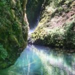
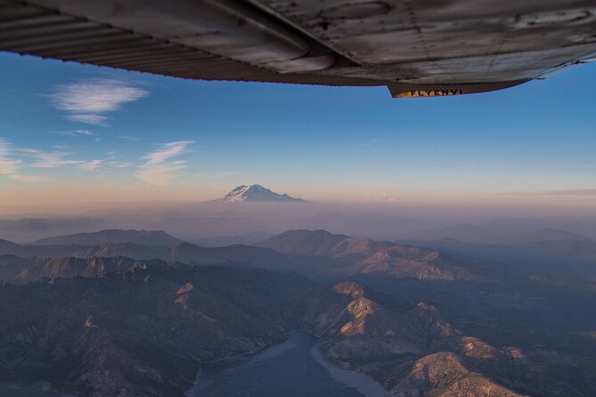
Stop 1: The Columbia River Gorge from above
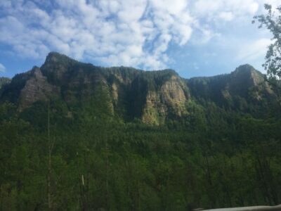
Your first aerial stop is the Columbia River Gorge National Scenic Area, a dramatic canyon carved by the Columbia River. The Gorge is described as 85 miles long, spanning portions of three Oregon and three Washington counties.
From the air, this is one of those places where you can quickly understand scale. On the ground, the Gorge can feel like a series of overlooks. In the sky, you see how the river cuts through the terrain, how the canyon walls stack up, and how towns and valleys line up along the waterway.
A practical consideration: canyon views depend heavily on cloud level. When visibility is decent, the Gorge can look crisp and layered. When visibility is poor, it can still be fascinating, but you may lose some sharpness in the depth.
Still, this is a strong opening because it sets the stage for everything else you’ll see—especially Portland’s rivers and the volcanic story that follows.
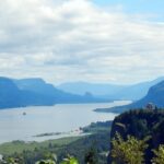
Stop 2: Portland and the shadow of Mount Hood
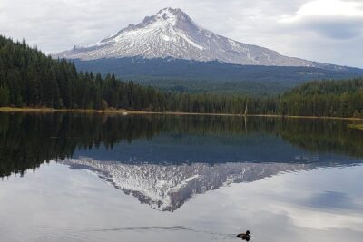
Next, the flight goes over Portland, Oregon’s largest city, located where the Columbia and Willamette rivers meet. The route is also framed as flying “in the shadow” of snow-capped Mount Hood, which matters for both geography and photo orientation.
From above, Portland is easier to read than you might expect. You can often pick up the river connections fast, and you get a sense of how neighborhoods, bridges, and river bends fit together. It’s also a good break in the intensity of the Gorge and volcano story—more urban and river geometry, less geology-only drama.
The weather can shape what you get with Mount Hood. If Hood is visible, it can anchor the trip visually and help you understand the region’s elevation changes. If it’s not clear, you’ll still be flying over Portland’s river system, which is the key feature here.


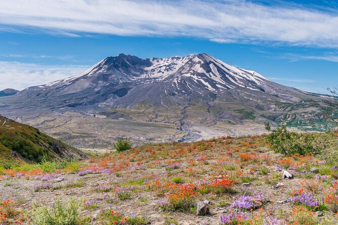
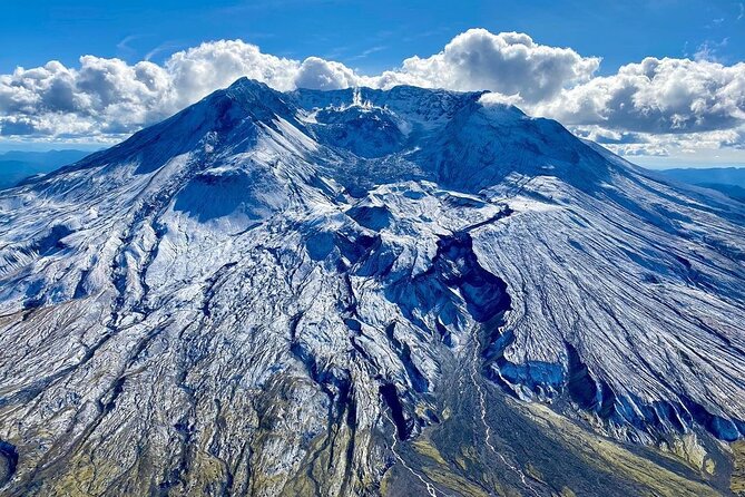
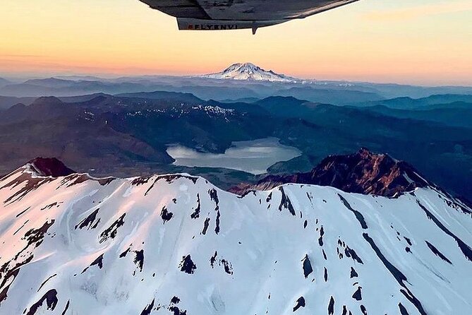
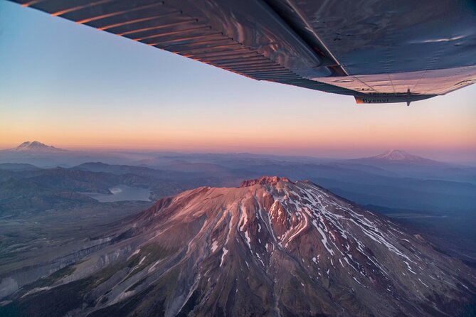
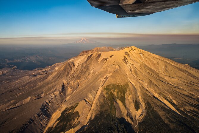
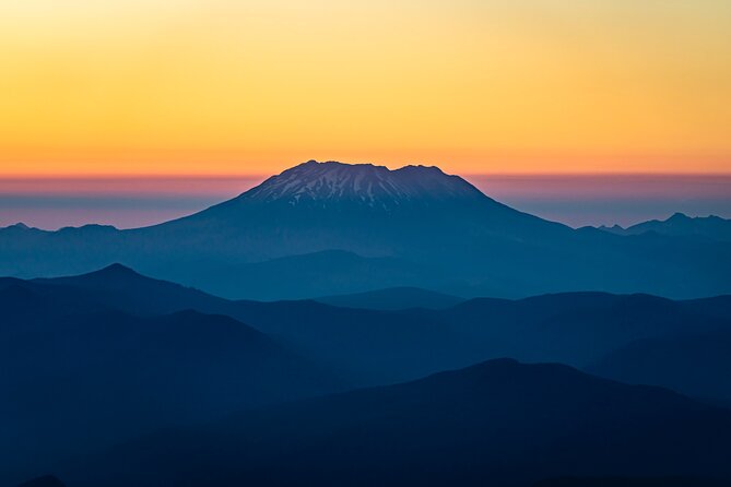
Stop 3: Mt. St. Helens crater views and the 1980 eruption story
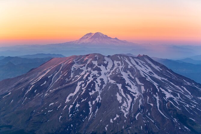
Then you get to the reason for the trip: flying around the crater of Mount St. Helens. The volcano is known for its major eruption on May 18, 1980, described as the deadliest and most economically destructive volcanic event in U.S. history.
Flying near a crater isn’t something you forget. Even with brief look angles, it helps you understand that a volcano isn’t just a distant point on a map. It’s a whole engineered landscape shaped by time—sometimes violently—then changed again by regrowth and aftermath.
This stop is also where the pilot narration becomes especially valuable. The best aerial tours don’t just show you a place; they give you orientation so the view clicks. One review specifically praised the pilot’s ability to explain what you’re seeing and how the volcanoes are positioned, and that kind of narration can make the crater and surrounding features feel far more meaningful.
A small expectation check: the crater view can depend on routing and cloud cover. But the core goal here is still to give you an aerial perspective on Mt. St. Helens and its setting in the region.
Stop 4: Seeing the destruction zones from the air
After the crater portion, the flight moves to views over the destruction from the eruption. That’s a different type of looking than “here’s a mountain.” You’re seeing how landscapes changed as a result of the event.
From above, destruction can look oddly geometric—less like scattered damage and more like patterns of impact across a wider area. That’s often what helps people make sense of how large the event was. On the ground, you can feel the story locally. From the sky, you feel the scale.
Again, this is strongly tied to visibility. If the air is clear, this can be one of the most striking moments. If clouds or haze interfere, you may get the context more than the fine details.
The pilot experience: safety, clarity, and practical storytelling
Several reviews highlight that the flight feels professional and safe. One passenger called out a pilot named John as very informative and knowledgeable about the sights, explaining landscapes as you fly over them. That kind of commentary is exactly what you want on an airplane tour because you’re moving fast and you can’t always pause to study the view.
The same review noted that a helicopter would have offered better visibility for picture-taking, which is a fair reality check. With an airplane, you’re at the mercy of seat location, wing position, and where the plane is in the sky. You’ll still likely get great moments, but you should avoid assuming every photo will be a perfect postcard.
My tip: bring your patience, not just your camera. If you want good shots, focus on timing the turn rather than trying to “capture everything.” When you get a clean view, snap a few photos and then look again. You’ll get more enjoyment that way.
Airplane vs. helicopter: what to expect for photos and comfort
This tour is operated with airplanes, not helicopters. That’s stated clearly, so you can plan accordingly.
Here’s the practical difference for your day:
- Smoother, steadier flight can help you track the view
- Different visibility can happen depending on window position and wing lines
- You may need to accept that some angles will be less ideal than a hovering aircraft
If your top priority is maximum window clarity for photos, be aware of that tradeoff. But if your main goal is perspective and understanding—why the area looks the way it does—an airplane tour can be the sweet spot.
Who this tour fits best (and who should reconsider)
This works best for you if:
- you want a big Oregon sampler in a short time
- you like learning from a pilot who explains what you’re seeing
- you’re planning around limited daylight and want a tight, focused experience
It may be less ideal if:
- you’re extremely weather-sensitive and would be disappointed by a route shift
- you need the absolute best photo visibility and close-up hovering angles
Also note the tour has a weight per passenger limit of 250 lbs, with group weight caps noted for small groups. You’ll be asked to provide weights when booking, and the maximum group size is 5. If you’re traveling as a family or with friends, check the group weight rules early so there are no surprises.
Value check: does the $355 price make sense?
For $355 per person, you’re paying for a few things at once: access to restricted “from above” viewpoints, a trained pilot’s local knowledge, and a compact 1-hour route that ties multiple iconic regions together.
A key value point is the small group size. In a larger aircraft, your experience can feel like a bus tour in the sky. Here, the ceiling of 5 travelers makes it more likely you’ll get clearer explanation and a more personal tone.
The other value component is the round-trip transport from Troutdale. Even if you could drive yourself, having it handled can reduce friction and make the whole day feel easier.
So the price isn’t bargain-basement, but it’s in line with what a serious aerial experience typically costs—especially one focused on Oregon’s high-impact sights.
Quick tips so you enjoy the flight more
- Pack a little flexibility. Weather can change your exact path, and that’s normal for this region.
- Arrive early so you’re not rushed, especially with a small group.
- Bring layers. Even when the day is warm on the ground, air temperatures can feel different up high.
- If photos matter, be ready to shoot in bursts when you get clean sightlines rather than waiting for a single perfect moment.
Should you book the Mt. St. Helens Air Tour with Envi Adventures?
If you want a short, high-impact Oregon experience and you’re happy to let the pilot adjust the route based on conditions, I think it’s an excellent choice. The combination of Columbia River Gorge scale, Portland’s river geography, and Mt. St. Helens’ crater and eruption aftermath is exactly the kind of “wow” that’s hard to replicate any other way.
I’d only hold off if you can’t handle weather changes or if helicopter-style close-up photo angles are your top priority. Otherwise, the small group feel, strong pilot narration (including praise for John’s explanations), and the tight one-hour format make this a very smart use of time around Portland.
FAQ
How long is the Mt. St. Helens Air Tour?
The tour is about 1 hour (approx.).
Where does the tour start and end?
It starts and ends at Envi Adventures, 1350 NW Perimeter Way, Troutdale, OR 97060, USA.
What is the price per person?
The price is $355.00 per person.
What aircraft is used for the tour?
This tour is operated with airplanes, not helicopters.
Is the route guaranteed to be the same?
No. The tour is very weather dependent, and the pilot may use alternate routing at their discretion.
How large is the group?
The experience has a maximum of 5 travelers.
Are there weight limits?
Yes. Total weight per passenger is limited to 250 lbs, with additional group weight caps noted for groups of 3 or 5. You’ll need to provide passenger weights when booking.
You Might Also Enjoy
More Tours in Portland
- The Real Portland Tour: City and 3 Lighthouses Historical Tour with a Real Local
★ 5.0 · 1,448 reviews
More Tour Reviews in Portland
- The Real Portland Tour: City and 3 Lighthouses Historical Tour with a Real Local
★ 5.0 · 1,448 reviews